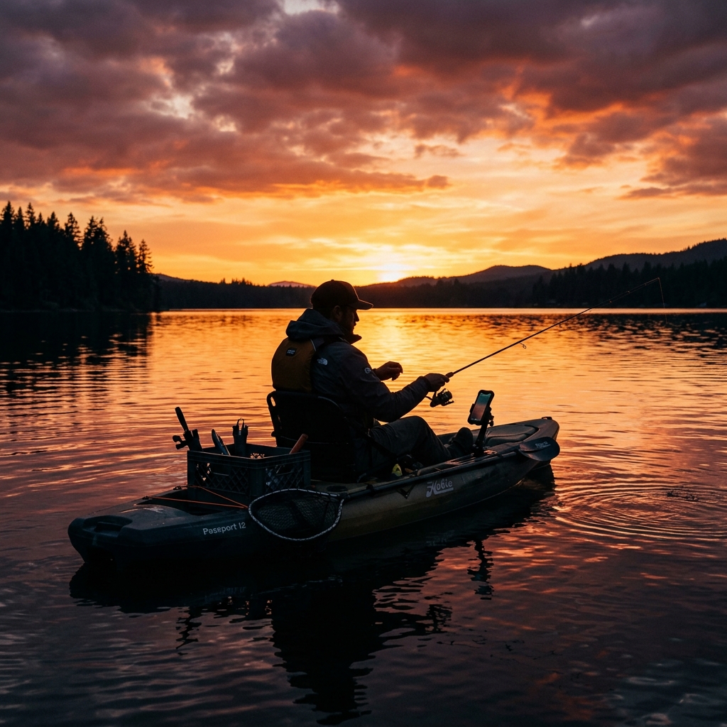
How to Save Fishing Spots with GPS
Technical Guide to Precision and Metadata
The Art of the Mark: Why a GPS Point is Not Enough
For the recreational or professional fisherman, a GPS mark is much more than simple latitude and longitude. It is the record of a submerged structure, a ledge, a solitary rock, or a wreck that has taken years to locate. However, most fishermen make the mistake of treating these locations as static data rather than dynamic assets.
Saving fishing spots with technical precision is the difference between spending the morning looking for a signal on the sonar or going straight to the action. In this CAPTA technical guide, we will break down how you can transform your traditional fishing logbook into an infallible tactical navigation system.
The Chaos of the Traditional Method: Fragmentation and Oblivion
Historically, the fisherman has depended on visual alignments (transits) and, later, on marks noted in wet notebooks or in the internal logs of plotters that are rarely synchronized with other devices. The result is the fragmentation of knowledge.
Relying on memory or disorganized photos in your mobile gallery is a recipe for disaster. A spot that was productive a year ago is lost due to lack of proper context: what was the wind like?, what phase of the tide were we in?, what was the water temperature? Without these metadata, the coordinate is only 20% of the story.
The Science of Thermal and Bathymetric Location
When you mark a point with CAPTA, you are doing much more than pressing a button. Current technology allows each waypoint to be a digital clone of the environment.
Critical factors to record:
- Substrate Type: It is not the same fishing over a seagrass meadow as over shale or live rock. When saving the point in CAPTA, you can add technical notes about the bottom hardness you saw on the sonar.
- The Thermal Layer (Thermocline): If you were fishing at 40 meters and detected a thermocline at 25m, that note in your waypoint is vital for the next season.
- Leeway and Drift: Your mobile GPS tells you where you are, but not necessarily where the bait is if there is a lot of current. Recording the drift direction in the spot note will allow you to position the boat correctly the next time you try to hit that rock.
Drift Calculation: The Secret of the Perfect Anchorage
One of the most common mistakes among fishermen who start using precision systems is anchoring exactly over the marked point. At sea, the sonar point and the point where your bait will fall rarely coincide due to current and wind.
To master tactical marking, you must apply the Vector Angle Calculation. If you have a Southeast current of 1 knot and a depth of 40 meters, your anchorage point should be approximately 60 to 80 meters upstream of your GPS mark. When saving your spot in CAPTA, it is essential to use the notes section to record that day's current intensity. This will allow you, months later, to know exactly where to drop the anchor so the drift deposits your rig over the head of the rock, and not a hundred meters away in the sand.
Stratification and Seasonality: Points that "Die" and "Revive"
A fishing spot is not productive 365 days a year. Migratory species and resident predators move according to water temperature and barometric pressure. A spot that was a gold mine at 20 meters depth in July may be completely deserted in December due to the disappearance of the thermocline.
By using CAPTA, you are creating a geolocated behavioral history. If you record that in March the specimens were concentrated on the east ledge with 1012 hPa of pressure, when those conditions repeat, you will receive a clear signal that it is time to return. Do not rely on intuition; rely on the data you have systematically harvested in each catch. True mastery consists of knowing which points to activate and which to let rest according to nature's cycles.
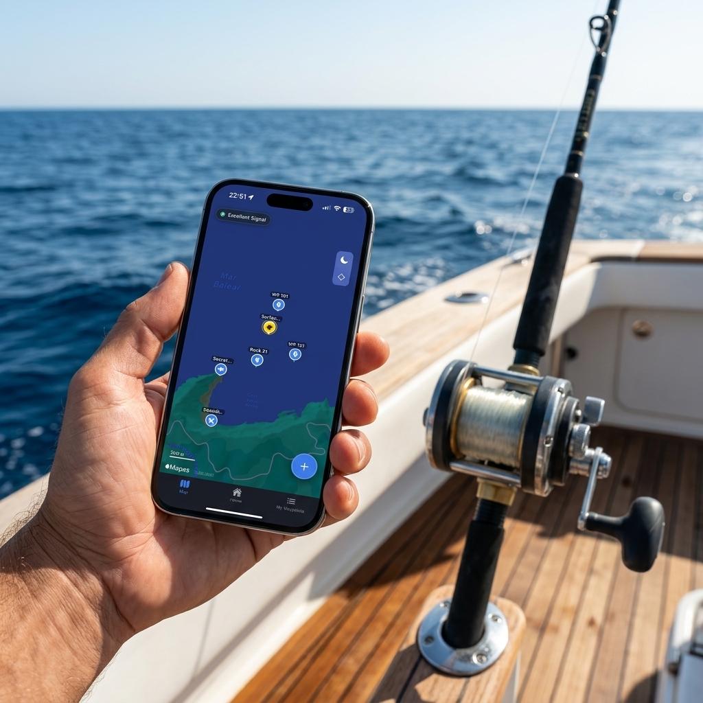
Tactical Visualization: Your Waypoint Map as a Competitive Advantage
Visibility is power. Having your fishing spots organized on an interactive map that works offline is the greatest advantage a fisherman can have today. By seeing your secret spots together, you begin to detect patterns: migration routes, feeding zones at low tide, and ledges connecting different structures.
Using a clean and professional interface like CAPTA allows you to manage hundreds of points without hassle, filtering them by date, species, or depth.
Hybrid Ecosystem: CAPTA as a Backup Brain
Even if you have the most advanced electronics from Garmin, Raymarine, or Furuno, using CAPTA as a backup system and digital diary is a decision of strategic intelligence. Onboard electronics can fail, batteries can drain, or waypoint files can be corrupted during a firmware update.
Maintaining your Mark Sanctuary on your smartphone using CAPTA guarantees total portability. If you change boats, go out with a friend, or are just at home planning the weekend's outing, you have instant access to your entire database with real photos of the bottom and associated catches. It is the perfect bridge between the raw power of an industrial plotter and the agile flexibility of a modern mobile device.
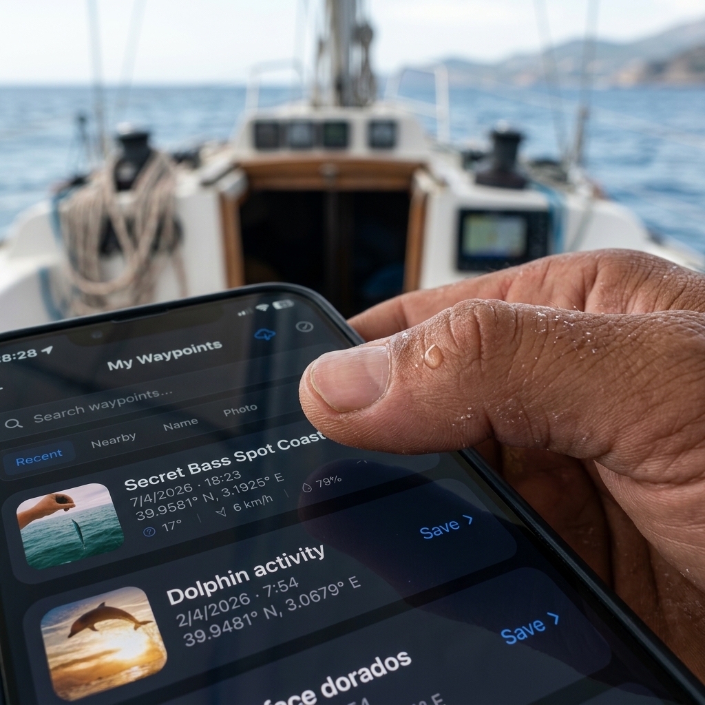
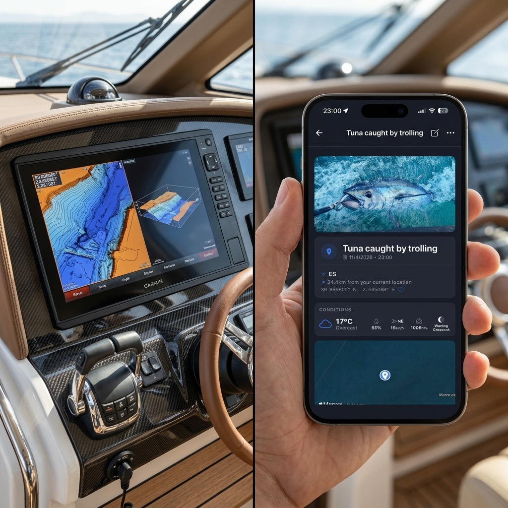
The Value of Automatic Metadata: CAPTA's "Tailwind"
One of the greatest secrets of successful fishermen is consistency. They return to spots when conditions are identical. When saving a point in CAPTA, the system invisibly and automatically records the barometric pressure, lunar phase, and wind.
Why is this revolutionary? Because fish don't feed the same at 1020 hPa as at 1005 hPa. Months later, you can filter your spots and say: "show me the spots that worked with North wind and spring tides." That's not luck; it's science applied to fishing.
Digitization in the Moment of Action
Fishing is a hostile environment for technology. Salt spray, scales, blinding sun, and wet hands. Taking out your mobile and typing 14 digits into a conventional map app is impossible and risky.
That's why the workflow must be instant. A single touch to mark, a quick photo of the sonar to save the bottom profile, and back to the rod. That is CAPTA's philosophy: minimize screen time to maximize fishing time, ensuring that data capture is natural and doesn't get in the way.
Legacy and Security: Protecting your "Secret Sanctuary"
A fisherman's greatest fear is that his marks fall into the wrong hands. Fishing social media apps or shared maps are the enemy of exclusivity.
Saving your spots in a closed and secure system like CAPTA ensures that your golden positions remain on your device. Furthermore, the ability to migrate your marks from old plotters by directly scanning the screen allows you to digitize decades of experience in a single afternoon.
FAQ: Frequently Asked Questions for Fishermen (Faq)
Are my fishing marks saved in a public cloud where others can see them?
Absolutely not. At CAPTA, we understand that discretion is sacred in the fishing world. Your marks and notes are private and stored on your device. Only you have access to your coordinate sanctuary, eliminating the risk of your secret spots being crowded with other boats due to an accidental data leak on a social network. It is a system designed by and for people who value the privacy of their findings.
Can I save a spot if I am fishing 20 miles offshore without coverage?
That is precisely CAPTA's specialty. The mobile GPS system is independent of the cellular data network. You can mark locations with centimeter precision in the middle of the ocean, add photos of the catch and sonar notes without needing a single bar of coverage. All information is processed locally and will be ready for immediate consultation.
How can I transfer my marks from an old plotter to CAPTA without typing them?
It is a mechanical process that CAPTA has simplified through computer vision. If you have a list of waypoints on your old device's screen or even on a paper map, simply point the CAPTA camera at those numbers. Our technical OCR engine will recognize the degrees, minutes, and seconds formats, capturing the data in seconds without possibility of typo.
Is CAPTA suitable for shore fishing or only for boats?
It is even more valuable from the shore, where visual references are often misleading. On a uniform coastline or on a breakwater at night, it is easy to lose the exact spot where a hole or a sunken sandbank is located. By marking it with CAPTA, you can use the compass and offline map to return to the exact same rock, ensuring your cast falls right in the feeding hot spot.
What metadata does CAPTA record besides the coordinate?
Automatically, CAPTA associates each point with the date, exact time, local weather conditions, and atmospheric pressure of the moment. This is not just to know what the weather was like, but to perform a scientific audit of your own results. Over time, you will discover invisible patterns about which points are productive in specific lunar phases or with specific currents.